Mumbai, August 22, 2025:
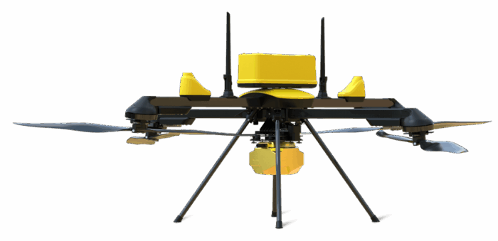
ideaForge Technology Limited, a global leader in drone technology, today unveiled its most versatile mapping UAV, the Q6V2 GEO, making its worldwide debut at PRAGYA 2025, the company’s inaugural customer event themed this year for Advancing Possibilities in Geospatial Intelligence. The launch marks a significant milestone in ideaForge’s mission to equip industries, government agencies, and researchers with cutting-edge aerial mapping and intelligence capabilities.
Advancing itself in the domain of drone technology, ideaForge Technology unveiled its most versatile mapping UAV, the Q6V2 GEO at PRAGYA 2025, the company’s inaugural customer event in Navi Mumbai. The launch marks a significant milestone in ideaForge’s mission to equip industries, government agencies, and researchers with cutting-edge aerial mapping and intelligence capabilities.
PRODUCT DETAIL & ITS USP
The Q6V2 GEO has been purpose-built to map anything, anywhere, with all-terrain performance, even in the most extreme environments. Whether it is glacier mapping in the Himalayas, surveying complex urban landscapes, conducting dense forest studies, or monitoring industrial corridors, the Q6V2 GEO delivers unmatched performance. This survey-grade UAV offers more than 50 minutes of flight time with a LiDAR payload, under 7 kg take-off weight, and exceptional accuracy through advanced IMU on-board, PPK-enabled geotagging and seamless CORS integration. Its five modular and third-party payloads make it one of the most versatile UAV platforms in its class, seamlessly switching between high-resolution photogrammetry, including the newly launched 61 MP AI-enabled payload – SHODHAM M61, LiDAR, oblique imaging, hyperspectral sensing, and thermal detection to address a wide range of used cases.
INDUSTRIES AND RESEARCH DOMAINS
Paired with ideaForge’s new geospatial tech stack, the Q6V2 GEO is poised to have an impact across industries and research domains. From LiDAR mapping of Himalayan glaciers for avalanche prevention, to high-resolution mapping of 12,000-year-old Konkan petroglyphs for archeological research and digital archiving, and large-scale urban mapping in Varanasi for municipal governance and agricultural productivity improvement, the stack empowers organisations to transform raw aerial data into actionable intelligence.
FLYGHT CLOUD
When combined with Flyght Cloud, ideaForge’s one-stop secure cloud-based platform that converts raw UAV data into accurate, decision-ready insights, the Q6V2 GEO delivers even greater value, enabling faster and smarter operations.
URBAN PLANNING
The Q6V2 GEO enables urban planning teams to build 3D city models and conduct infrastructure audits, helps the mining sector calculate volumes and automate compliance reports, and supports utility companies with tower inspections and vegetation risk assessments. It also empowers forestry and water resource managers with biomass analysis and habitat monitoring, equips farmers with early crop stress detection tools, and aids disaster response agencies with rapid terrain assessments in high-altitude and remote regions.

Ankit Mehta, CEO, ideaForge states:“The Q6V2 GEO, along with our entire geospatial tech stack, is a leap forward in geospatial intelligence, offering our customers the ability to operate in the most demanding terrains and climates with ease and precision. From mapping remote glaciers to surveying bustling urban corridors, this platform reflects our commitment to building solutions that truly advance possibilities. At ideaForge, our goal is to empower organisations and decision makers to see, understand, and act on their world like never before, completing the geospatial mapping picture with a platform that delivers high performance and unlocks missions once thought impossible.”
GLOBAL LAUNCH AT PRAGYA 2025
ideaForge’s annual inaugural customer event PRAGYA 2025 was themed “Advancing Possibilities in Geospatial.” The industry also witnessed the global launch of Q6V2 GEO positioning the geospatial tech stack as a next-generation aerial mapping solution available to customers and partners across the world. At the event, a whitepaper was released from ideaForge on the transformative applications of drones in the industry, across sectors, offering deep insights into how UAVs are reshaping the way organisations map, monitor, and manage environments while processing geospatial and intelligence data with greater speed and precision.
The event further showcased ideaForge’s mission-ready payloads and advanced software tools, including BlueFire Touch (BFT) with enhanced communication and safety with features such as frequency hopping, auto-channel selection for resilient communication, and geofencing with obstacle height definition. It also improves productivity with multi-polygon flight planning, KML export, multi-UAV coordination (upcoming), and area coverage checks. Special capabilities include the ability to upload a custom Digital Elevation Model (DEM) for accurate terrain following, which is essential for safe and accurate mapping of powerlines, mines and congested urban environments. Airborne Data Relay (ADR) enables mapping and inspection in terrains where line-of-sight is unavailable, along with geotagged video capture—empowering organizations to extract insights and make informed decisions from the data collected.